Calling a halt to land take in Flanders

Margo Bienstman, Ann Pisman, Isabelle Loris and Stijn Vanderheiden, Department of Environment and Spatial Development Flanders
Preserving open space is crucial in creating a sustainable region, supporting natural resources, biodiversity, a healthy living environment and climate mitigation. However, the growing population and economy continually demand more space, placing significant pressure on non-built-up areas. Flanders, as one of the most highly frequented and populous regions in Europe, faces challenges in striking a balance between growth and preserving open space.
Flemish ambitions
The competence for environmental policies in Belgium has been transferred to each region. Flanders, the Northern and Flemish-speaking part of Belgium, has formulated a strategic vision to reduce net land take. The goal is to reduce net land take from 6 ha/day in 2016 to 0 ha/day in 2040, with an intermediate target of 3 ha/day by 2025. This means This article gives a brief overview of the region's goals and challenges in managing this delicate equilibrium. Key trends and developments in Flemish settlement areas are highlighted.

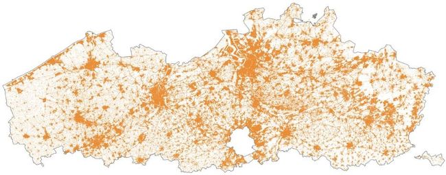
Scattered nature of the settlement areas in Flanders (2022)/ source: the authors
Settlement area
The European Environment Agency (2012) defines a settlement area as "the area of land used for housing, industrial and commercial purposes, health care, education, nursing infrastructure, roads and rail networks, recreation (parks and sports grounds), etc. In land use planning, it usually corresponds to all land uses beyond agriculture, semi-natural areas, forestry, and water bodies." In 2016, Flanders introduced a definition that is very similar to the settlement area but also includes agricultural constructions such as stables and greenhouses. Settlement areas reached 32.4 % of Flanders' total area in 2022. This makes it one of Europe's most densely developed regions. that between 2020 and 2040 the additional land take should be limited to 16 400 ha. The negative consequences of the extensive spatial expansion and sprawling settlement layout in Flanders, such as floods, soil degradation and reduced biodiversity, are starting to show. Flanders' highly ambitious objective of reducing land take is reflected in the urgency with which it aims to preserve open space.
Evolution of land take in Flanders
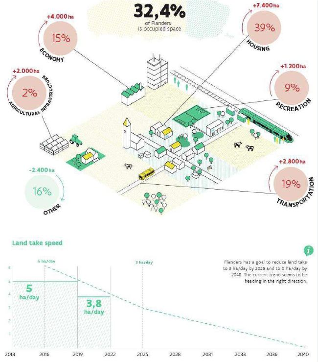
Between 2013 and 2022, additional land take amounted to 15 000 ha, resulting in a total settlement area of 441 500 ha in 2022, or 32.4 % of Flanders' total land. This is the result of both an increase (26 000 ha) and a decrease (11 000 ha) in land take. Although land take increased annually, the rate at which open space was taken reduced from an average of 5 ha/day (2013-2019) to 3.8 ha/day (2019-2022). The goal of reaching 3 ha/day by 2025 is therefore within reach.
Flanders strategic vision to reduce net land take means that between 2020 and 2040 the additional land take should be limited to 16.400 ha
Housing (including gardens), which takes up more than a third of the total settlement area, saw the largest absolute increase in land take, namely 7 400 ha in 2013-2022. Transport infrastructure is the second largest occupier of space (19 %), with an additional 2 800 ha taken up in the last decade. Economic land use, such as for industry, retail and services, accounts for 15 % of the settlement area. The settlement area used for these purposes increased by 4 000 ha in 2013-2022. In general, the slow decrease in overall land take since 2019 (from 5 ha/day to 3.8 ha/day) can be seen in all the land use categories. Only agricultural constructions, which take up only 2 % of the settlement area, exhibited a slightly atypical course: first a steep increase from 2013 to 2019, followed by an actual decrease in settlement area.

No Net Land Take in Flanders - evolution between 2013 and 2022/ source: the authors
Flanders, as one of the most intensively used and inhabited regions in Europe, faces challenges in striking a balance between growth and preserving open space.
Owing to the gradual reduction of the land take rate and an increase in the Flemish population, the average space per resident decreased slightly between 2013 and 2022, from 664 sqm to 659 sqm. This indicates a modest densification of Flanders' built-up fabric. However, the space per resident is still relatively large, partly because of the extensive urban sprawl in the region.
Lastly, there are some areas more suitable for settlement than others. For example, forests, nature reserves and agricultural fields are less favourable than other areas. However, in 2013 a third of the settlement area lay in these less suitable areas. Of the 15 000 ha of land that was taken during 2013 and 2022, 6 400 ha was taken in these 'green' spaces. Some of the land included agricultural constructions, but housing and transport also took up a lot of space.
Conclusion
The shift towards reduced land take that began in 2013 is progressing as intended by policymakers, although the specific role of policies in this matter remains to be seen. It remains crucial to continue promoting the maximum protection of open spaces and the optimisation of existing settlement areas. Regional differentiation is essential to balance the needs of both residents and the planet, guiding Flanders towards a sustainable future.
Margo Bienstman, Ann Pisman, Isabelle Loris and Stijn Vanderheiden, Department of Environment and Spatial Development Flanders